
Keyword
Earth Science Services | Models | Earth Science Reanalyses/Assimilation Models
11 record(s)
Type of resources
Topics
Keywords
Contact for the resource
Provided by
Formats
Update frequencies
Status
draft
-
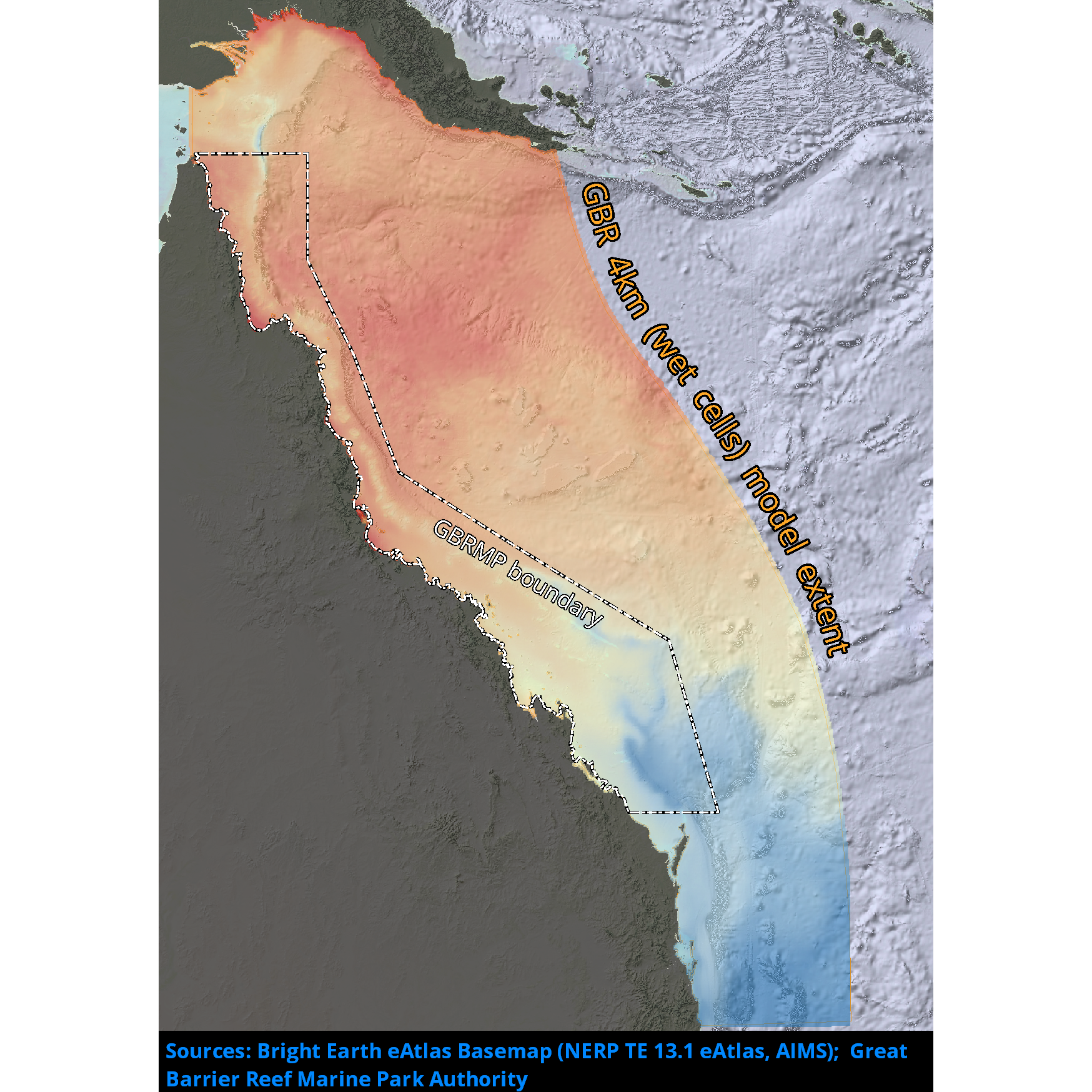
Passive river tracer results derived from version 2.0 of the 4km-resolution regional-scale hydrodynamic model of the Great Barrier Reef (GBR4). This model configuration and associated results dataset may be referred to as "GBR4_H2p0_Rivers" according to the eReefs simulation naming protocol. The model runs in near-real-time mode, updating daily.
-
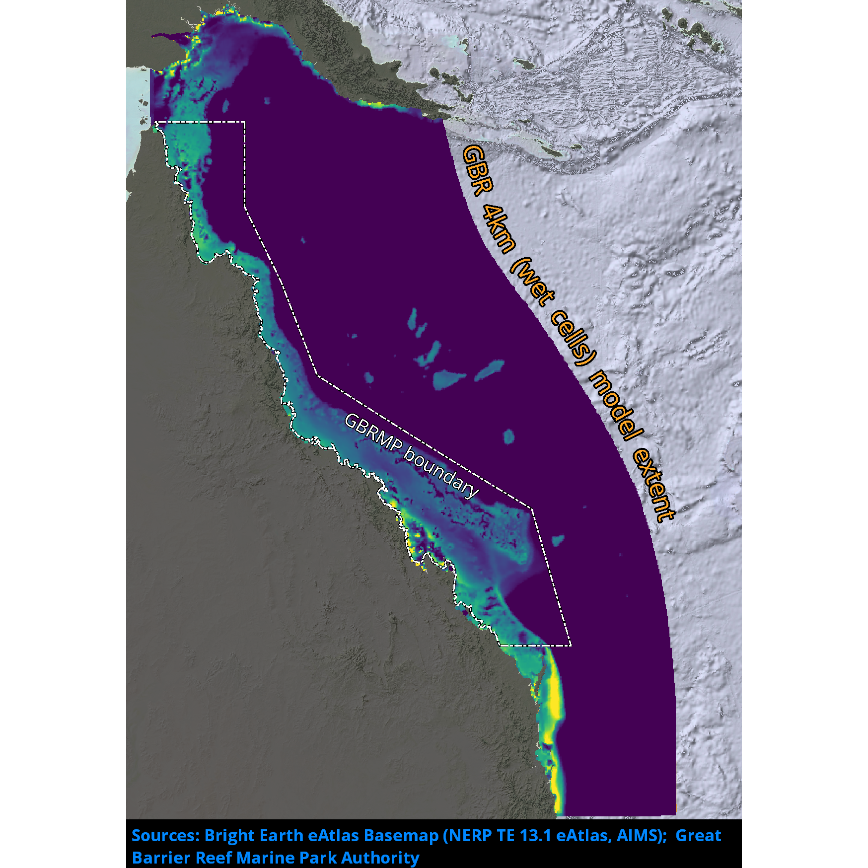
Passive river tracer results derived from version 2.0 of the 1km-resolution shelf-scale hydrodynamic model of the Great Barrier Reef (GBR1). This model configuration and associated results dataset may be referred to as "GBR1_H2p0_Rivers" according to the eReefs simulation naming protocol. The model runs in near-real-time mode, updating daily.
-

DEPRECATED: This dataset has been superseded by GBR4_H2p0. It will be decommissioned in April 2024. Results from version 1.85 of the 4 km resolution regional-scale hydrodynamic model of the great Barrier Reef (GBR4). It was forced with BlueLink OceanMAPS data on the open boundaries and Bureau of Meteorology model ACCESS-R for surface atmospheric data. The tide was introduced through 22 constituents derived from the global CSR tide model, and 22 river boundaries incorporated measured stream flow and temperature data from QLD DNRM's gauging stations. This model version was published for reference in the SIEF report from January 2016, but was later discovered to have been forced with incorrect (multiplicative error) rainfall levels, and the 2015 results contain salinity errors. This model configuration and associated results dataset may be referred to as "GBR4_H1p85" according to the eReefs simulation naming protocol.
-

DEPRECATED: This dataset has been superseded by GBR1_H2p0 and it will be decommissioned in April 2024. Results from an early version of the 1km-resolution shelf-scale hydrodynamic model of the Great Barrier Reef (GBR1). This version of the model was forced by version 1.85 of the eReefs GBR 4 km resolution hydrodynamic model, and the results were made available for comparison purposes only. This model configuration and associated results dataset may be referred to as "GBR1_H1p71" according to the eReefs simulation naming protocol.
-

Results from version 3.1 of the the 4km-resolution biogeochemistry and sediments model of the Great Barrier Reef (GBR4), forced by version2 of the Hydrodynamic model and by a reduced-loads catchment scenario which is derived from SOURCE Catchments with 2019 catchment condition (q3b) with anthropogenic loads (q3b – q3p) reduced according to the percentage reductions of DIN, PN, PP and TSS specified in the Reef 2050 Water Quality Improvement Plan (WQIP) 2017-2022 as calculated in Brodie et al., (2017). Further, the reductions are adjusted to account for the cumulative reductions already achieved between 2014 and 2019 that will be reflected in the 2019 catchment condition used in q3b. This model configuration and associated results dataset may be referred to as "GBR4_H2p0_B3p1_Cq3R_Dhnd" according to the eReefs biogeochemical simulation naming protocol. The model ran in hindcast-mode as one of a suite of simulations which included baseline (GBR4_H2p0_B3p1_Cq3b_Dhnd) and pre-industrial (GBR4_H2p0_B3p1_Cq3p_Dhnd) catchment scenarios.
-

Results from version 3.1 of the 4km-resolution regional-scale biogeochemistry and sediments model of the Great Barrier Reef (GBR4), forced by version 2.0 of the 4km-resolution hydrodynamic model and with Furnas relationships for wet and dry tropics rivers as catchment inputs. This model configuration and associated results dataset may be referred to as "GBR4_H2p0_B3p1_Cfur_Dnrt" according to the eReefs biogeochemical simulation naming protocol. The model runs in near-real-time mode, updating daily.
-
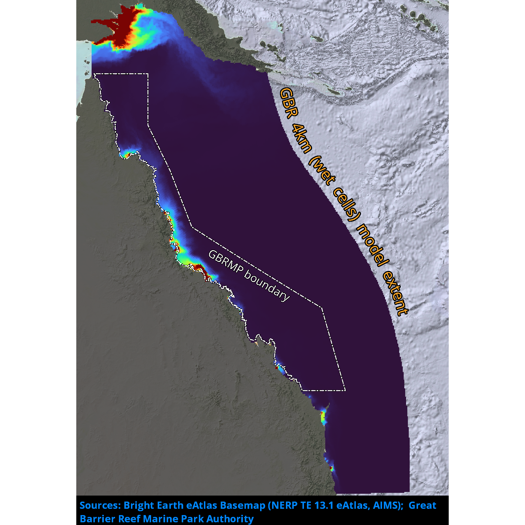
Results from version 2.0 of the 4km-resolution regional-scale hydrodynamic model of the Great Barrier Reef (GBR4). This model is forced with BlueLink Ocean Modelling and Prediction System (OceanMAPS) model results on the ocean boundaries and Bureau of Meteorology ACCESS-R model for surface atmospheric data. The tide is introduced through 22 constituents derived from the global CSR tide model, and the river boundaries incorporate measured stream flow and temperature data from QLD DNRM's gauging stations for 22 rivers, and estimated flows and loads for 49 additional rivers. There are no known forcing problems. This model configuration and associated results dataset may be referred to as "GBR4_H2p0" according to the eReefs simulation naming protocol. The model runs in near-real-time mode, updating daily.
-
Results from version 3.1 of the 4km-resolution regional-scale biogeochemistry and sediments model of the Great Barrier Reef (GBR), forced by version 2.0 of the 4km-resolution hydrodynamic model and with catchment forcing from P2R SOURCE Catchments with pre-industrial catchment condition from December 01, 2018 to June 30, 2018 and then Empirical SOURCE Catchments with pre-industrial catchment condition from July 1, 2018 to April 30, 2019. This model configuration and associated results dataset may be referred to as "GBR4_H2p0_B3p1_Cq3p_Dhnd" according to the eReefs biogeochemical simulation naming protocol. The model ran in hindcast-mode as one of a suite of simulations which included baseline (GBR4_H2p0_B3p1_Cq3b_Dhnd) and reduced-load (GBR4_H2p0_B3p1_Cq3R_Dhnd) catchment scenarios.
-

Results from version 3.1 of the 4km-resolution biogeochemistry and sediments model of the Great Barrier Reef (GBR4), forced by version 2.0 of the 4km-resolution hydrodynamic model and by a baseline catchment scenario which is derived from P2R SOURCE Catchments with 2019 catchment condition from December 1, 2010 to June 30, 2018 and from empirical SOURCE Catchments with 2019 catchment condition from July 1, 2018 to April 30, 2019. This model configuration and associated results dataset may be referred to as "GBR4_H2p0_B3p1_Cq3b_Dhnd" according to the eReefs biogeochemical simulation naming protocol. The model ran in hindcast-mode as one of a suite of simulations which included pre-industrial (GBR4_H2p0_B3p1_Cq3p_Dhnd) and reduced-load (GBR4_H2p0_B3p1_Cq3R_Dhnd) catchment scenarios.
-
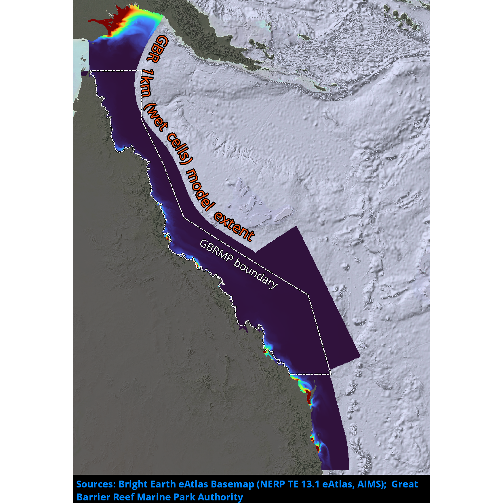
Results from version 2.0 of the 1km-resolution shelf-scale hydrodynamic model of the Great Barrier Reef (GBR1). This model is nested within version 2.0 of the 4km-resolution hydrodynamic model (GBR4) data at the ocean boundaries, uses the Bureau of Meteorology ACCESS-R model for surface atmospheric data and incorporates measured flow data from gauging stations at the river boundaries from QLD DNRM. This model configuration and associated results dataset may be referred to as "GBR1_H2p0" according to the eReefs simulation naming protocol. The model runs in near-real-time mode, updating daily.